
Suunto MC-2 G 6400/360 Military Compass


Description
Suunto MC-2 G 6400/360 Military Compass
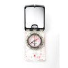
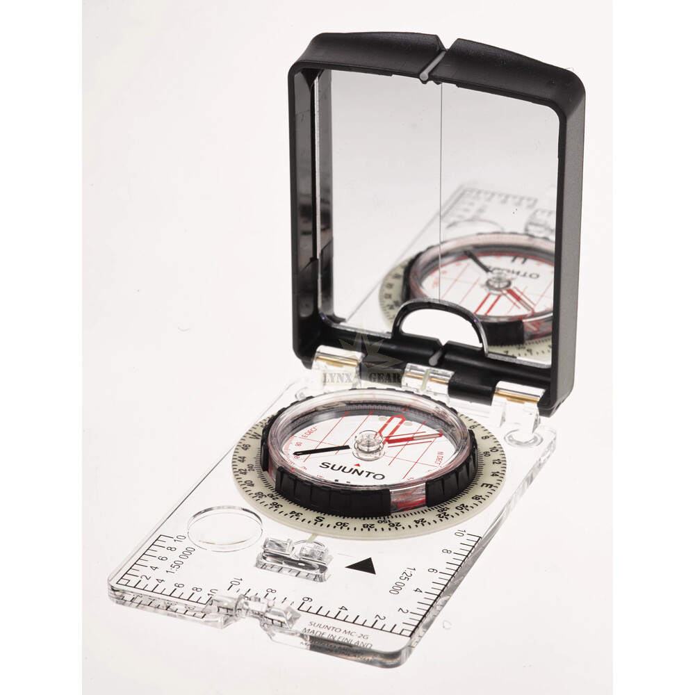
Suunto MC-2 G 6400/360 Military Compass is a professional field navigation tool built for demanding military, rescue and expedition use. It combines a transparent rectangular baseplate with a rotating protractor capsule, adjustable declination correction, and a hinged mirror lid for accurate sighting. The compass is non-radioactive, magnetic, unmounted and designed to remain reliable in extreme weather conditions.
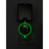
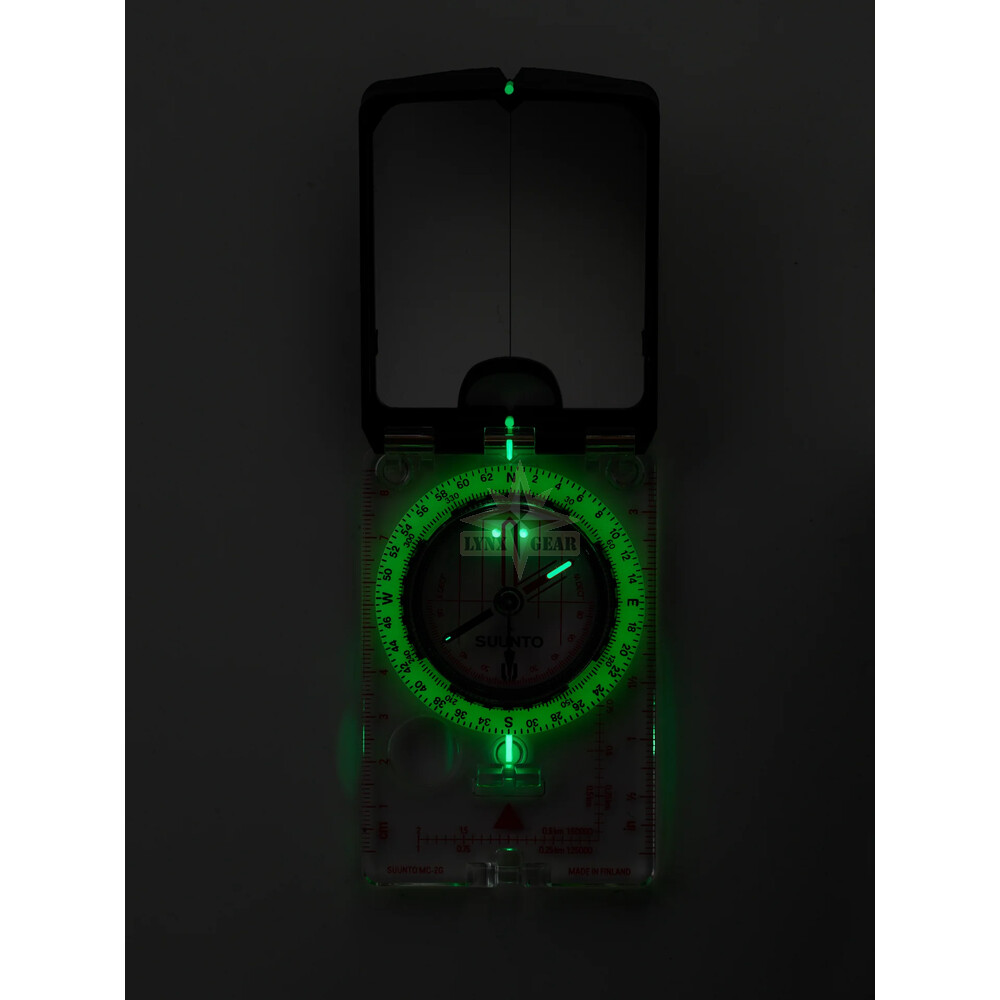
This version includes a MILS (0–6400) primary scale for MGRS-style work and a 0–360° secondary scale, plus a global balancing needle that functions across all magnetic zones worldwide. A built-in clinometer and extensive luminescent markings support advanced field use, including slope measurement and night navigation.
Key Features
- Suunto item: SS050629000
- NSN code: 6605-17-110-8584
- Primary scale: MILS 0–6400′ (50′ resolution)
- Secondary scale: 0–360° (2° resolution)
- Mirror sighting with luminous V-sights and center line
- Global needle for all magnetic zones
- Adjustable declination (±90°) using tool on lanyard
- Clinometer for slope/inclination measurement
- Liquid-damped, non-freezing, bubble-free capsule
- Impact- and scratch-resistant transparent baseplate (PMMA)
- Full luminescent features for night navigation
Physical Specifications
| Product dimensions | 65 × 101 × 18 mm |
| Net weight | 74 g |
| Package dimensions | 180 × 120 × 25 mm |
| Operational temperature range | -30 °C to +60 °C |
| Storage temperature range | -30 °C to +60 °C |
| Waterproofness | Waterproof to all practical depths (cavities fill with water and drain) |
Baseplate, Rulers & Optics
- Baseplate: rectangular, transparent, impact- and scratch-resistant PMMA
- Magnifying lens: Yes, 5×
- Rulers: cm and inch
- UTM roamers: metric partial 1:25 000 and metric 1:50 000
- Slope rulers: on the sides of the mirror lid
Protractor & Needle Specifications
- Protractor diameter: 59 mm
- Primary direction scale: MILS 0–6400′ clockwise (50′ resolution; numbered every 200′)
- Secondary direction scale: Degrees 0–360° clockwise (2° resolution; numbered every 30°)
- Cardinal markings: N, E, S, W
- Needle: red north / black south, luminescent north area, markings on both sides
- Needle length: 36 mm
- Magnet: NdFeB ring-shaped magnet in hub
- Capsule: hermetically sealed PMMA, diameter 44 mm
- Damping: non-freezing transparent liquid, bubble-free within operating range at sea level
- Orienting arrow: red/black under rotating capsule
Declination Correction
The angle between the orienting arrow and orienting lines can be adjusted to compensate for declination. Adjustment is done by turning the sprocket with the flat screwdriver tool on the lanyard. The correction scale is in degrees (2° resolution), numbered every 20°, extending 90° E (+) and 90° W (-).
Clinometer
- Feature: black weighted needle for inclination measurement when compass is held vertically
- Scale: degrees 0 to ±90° with 2° resolution
Sighting Tools & Mirror Lid
- Mirror inside black protective lid with center line
- Mirror can be tilted to any angle above the compass
- Lid protects the protractor assembly when closed
- V-sight on top and V-sight hole at base, aligned with center line and luminous
- Lid aligns with baseplate edges for a long straight-line tool on maps
- Catch locks the lid closed for transport
Luminescent Features
- Luminescent material: SrAl2O4
- Needle: luminescent north area + narrow line at south end
- Orienting arrow: two dots near the north end
- Protractor: luminescent material under printed scale
- Protractor index: luminescent forward bearing index + back-bearing index line
- Direction of travel: luminescent material under printed marking
Attachment
- 1 m black IR non-reflective lanyard
- Wrist lock
- Declination adjustment tool on lanyard
- Quick release
User Guide
- Paper with product: Yes
- Online: Yes (via Suunto support)
FAQ
What is the difference between 6400 mil and 360°?
Both scales represent a full circle. Degrees use 360 units, while the military mil scale uses 6400 units, allowing finer angular measurements for tactical navigation and target/bearing work.
Is this compass suitable for worldwide use?
Yes. The global balancing needle works across all magnetic zones and is designed to function at all Earth magnetic field locations.
How do I adjust declination on the MC-2 G?
Declination is adjusted using the flat screwdriver tool attached to the lanyard. The correction scale is in degrees with 2° resolution and supports ±90° east/west adjustment.
What is the clinometer used for?
The clinometer measures slope/inclination (0 to ±90°). It is useful for terrain evaluation, route planning, and estimating gradients in the field.
Is the compass waterproof?
Yes. It is waterproof to all practical depths. Any cavities may fill with water and then drain after exposure.
Glossary
- MGRS: Military Grid Reference System used with map grids for precise navigation
- MILS (mil-radians): Angular unit commonly used in military applications; 6400 mil equals a full circle
- Declination: Difference between magnetic north and true north, adjusted for accurate map navigation
- Clinometer: Instrument function for measuring slope/inclination angles
- Global needle: Compass needle balancing method designed to work in all magnetic zones worldwide
Manufacturer / GPSR Information
Suunto
Tammiston kauppatie 7 A
FI-01510 Vantaa
Finland
Customer support: Suunto Support
Specifications may change without notice as part of continuous product development.
Total Reviews: 0
Average Rating:
5 Star 0
4 Star 0
3 Star 0
2 Star 0
1 Star 0